Modell-iskola
Tényleg elég "sarkos" megfogalmazás, finoman szólva. Neten lehet találni GFS vs. WRF verifikációkat és egyik sem ilyen lesújtó, mint amit írsz, sõt.
De ajánlom az egyik WRF workshop anyagot: "Is the WRF better than the GFS?" Link

De ajánlom az egyik WRF workshop anyagot: "Is the WRF better than the GFS?" Link
Hosszabb távon (5-7 napnál távolabbi idõpontban) egyik modellbõl sem érdemes messzemenõ következtetéseket levonni, mert ott már a modellek általában olyan helyzeteket vázolnak fel, amire van esély, de nem sok. Pl.: kb. egy hete a GFS 15-18 fokos maximumokat várt országosan a mai napra, az eredmény pedig látszik. Rövidebb távon viszont van a GFS-ben némi hõmérséklet-alábecslés, de ez általában csak 1-2 fok. (Van olyan modell is, ahol ez akár a 3-5 fokot is elérheti, bár itt nyugaton a fõnös helyzeteket a GFS sem kezeli még jól.)
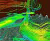
A WRF és az MM5 valóban a rövid távú (24-36 órás) elõrejelzésekhez jó, ahogy írták már elõttem is. A konvektív csapadékot általában jól meg szokták fogni, és az MM5 szélelõrejelzése is elég pontos, talán kicsit jobb is, mint a GFS-é. A WRF pedig a helyi konvergenciákat látja, így abból is lehet következtetni arra, hogy hol van nagyobb esély záporok, zivatarok kialakulására.
A WRF és az MM5 valóban a rövid távú (24-36 órás) elõrejelzésekhez jó, ahogy írták már elõttem is. A konvektív csapadékot általában jól meg szokták fogni, és az MM5 szélelõrejelzése is elég pontos, talán kicsit jobb is, mint a GFS-é. A WRF pedig a helyi konvergenciákat látja, így abból is lehet következtetni arra, hogy hol van nagyobb esély záporok, zivatarok kialakulására.

Azért az új WRF már a nagyobb csapadékrendszereket is szépen megfogta a télen.

A WRF nem feltétlenül arra való, hogy nagyobb térségû folyamatokat fogjon meg. Számtalanszor vettem észre énis alá vagy éppen túlbecsült hõmérsékleteket rajta.
Zivatarszezon alkalmával viszont néha nélkülözhetetlen, már láttam olyat, hogy szinte kilóméterre pontosan adta meg a zivatarcellák mozgását.
Én a WRF-t sose használom nagyobb térségû folyamatokhoz, de a konvektív eseményekre szerintem tökéletesen megfelel (persze ott se tökéletes, de sokszor pontosabb, mint a GFS mondjuk)

Talán még késõbb jól jöhet.
A GFS fõfutásban számolt paraméterek, változók - a teljesség igénye nélkül:
no4LFTXsfc ** surface none Best (4 layer) Lifted Index [k]
no5WAVA500mb ** 500 mb none 5-Wave Geopotential Height Anomaly [gpm](hidden)
no5WAVH500mb ** 500 mb none 5-Wave Geopotential Height [gpm](hidden)
ABSV ** (1000 975 950 925 900 850 800 750 700 650 600 550 500 450 400 350 300 250 200 150 100 70 50 30 20 10) none Absolute Vorticity
ACPCPsfc ** surface acc Convective Precipitation (hidden)
ALBDOsfc ** surface ave Albedo [%]
APCPsfc ** surface acc Total Precipitation
CAPEsfc ** surface none Convective Available Potential Energy
CAPE180_0mb ** 180-0 mb above ground none Convective Available Potential Energy
CFRZRsfc ** surface ave Categorical Freezing Rain (yes=1; no=0) [non-dim]
CICEPsfc ** surface ave Categorical Ice Pellets (yes=1; no=0) [non-dim]
CINsfc ** surface none Convective Inhibition
CIN180_0mb ** 180-0 mb above ground none Convective Inhibition
CLWMR ** (1000 975 950 925 900 850 800 750 700 650 600 550 500 450 400 350 300 250 200 150 100) none Cloud Mixing Ratio
oCPRAT ** surface ave Convective Precipitation Rate (hidden)
CRAINsfc ** surface ave Categorical Rain (yes=1; no=0) [non-dim]
CSNOWsfc ** surface ave Categorical Snow (yes=1; no=0) [non-dim]
CWATclm ** entire atmosphere (considered as a single layer) none Cloud Water
oCWORKclm ** entire atmosphere (considered as a single layer) ave Cloud Work Function (hidden)
oDLWRFsfc ** surface ave Downward Long-Wave Rad. Flux (hidden)
oDSWRFsfc ** surface ave Downward Short-Wave Rad. Flux (hidden)
GFLUXsfc ** surface ave Ground Heat Flux
GPA1000mb ** 1000 mb none Geopotential Height Anomaly [gpm] (hidden)
GPA500mb ** 500 mb none Geopotential Height Anomaly [gpm] (hidden)
HGTsfc ** surface none Geopotential Height [gpm] (hidden)
HGT ** (1000 975 950 925 900 850 800 750 700 650 600 550 500 450 400 350 300 250 200 150 100 70 50 30 20 10) none Geopotential Height [gpm]
HGT2pv ** PV=2e-06 (Km^2/kg/s) surface none Geopotential Height [gpm] (hidden)
HGTneg2pv ** PV=-2e-06 (Km^2/kg/s) surface none Geopotential Height [gpm] (hidden)
HGTtop0C ** highest tropospheric freezing level none Geopotential Height [gpm]
HGT0C ** 0C isotherm none Geopotential Height [gpm]
HGTmwl ** max wind none Geopotential Height [gpm]
HGTtrop ** tropopause none Geopotential Height [gpm]
HPBLsfc ** surface none Planetary Boundary Layer Height [m]
ICECsfc ** surface none Ice Cover [proportion]
LANDsfc ** surface none Land Cover (1=land, 0=sea) [proportion]
LFTXsfc ** surface none Surface Lifted Index [k]
oLHTFL ** surface ave Latent Heat Net Flux (hidden)
O3MR ** (100 70 50 30 20 10) none Ozone Mixing Ratio
PEVPRsfc ** surface none Potential Evaporation Rate (hidden)
POTsig995 ** 0.995 sigma level none Potential Temperature [k]
oPRATE ** surface ave Precipitation Rate (hidden)
PRESsfc ** surface none Pressure [pa]
PRES2pv ** PV=2e-06 (Km^2/kg/s) surface none Pressure [pa](hidden)
PRESneg2pv ** PV=-2e-06 (Km^2/kg/s) surface none Pressure [pa](hidden)
PRESlclb ** low cloud bottom level ave Pressure [pa]
PRESlclt ** low cloud top level ave Pressure [pa]
PRESmclb ** middle cloud bottom level ave Pressure [pa]
PRESmclt ** middle cloud top level ave Pressure [pa]
PREShclb ** high cloud bottom level ave Pressure [pa]
PREShclt ** high cloud top level ave Pressure [pa]
PREScclb ** convective cloud bottom level none Pressure [pa]
PREScclt ** convective cloud top level none Pressure [pa]
PRESmwl ** max wind none Pressure [pa]
PREStrop ** tropopause none Pressure [pa]
PRMSL ** mean sea level none Pressure Reduced to MSL [pa]
PWATclm ** entire atmosphere (considered as a single layer) none Precipitable Water
RH ** (1000 975 950 925 900 850 800 750 700 650 600 550 500 450 400 350 300 250 200 150 100) none Relative Humidity [%]
RH2m ** 2 m above ground none Relative Humidity [%]
RHsg330_1000 ** 0.33-1 sigma layer none Relative Humidity [%] (hidden)
RHsg440_1000 ** 0.44-1 sigma layer none Relative Humidity [%] (hidden)
RHsg720_940 ** 0.72-0.94 sigma layer none Relative Humidity [%] (hidden)
RHsg440_720 ** 0.44-0.72 sigma layer none Relative Humidity [%] (hidden)
RHsig995 ** 0.995 sigma level none Relative Humidity [%]
RH30_0mb ** 30-0 mb above ground none Relative Humidity [%]
RHclm ** entire atmosphere (considered as a single layer) none Relative Humidity [%]
RHtop0C ** highest tropospheric freezing level none Relative Humidity [%]
RH0C ** 0C isotherm none Relative Humidity [%]
oSHTFL ** surface ave Sensible Heat Net Flux (hidden)
SOILW0_10cm ** 0-0.1 m below ground none Volumetric Soil Moisture Content [fraction]
SOILW10_40cm ** 0.1-0.4 m below ground none Volumetric Soil Moisture Content [fraction]
SOILW40_100cm ** 0.4-1 m below ground none Volumetric Soil Moisture Content [fraction]
SOILW100_200cm ** 1-2 m below ground none Volumetric Soil Moisture Content [fraction]
SPFH2m ** 2 m above ground none Specific Humidity
SPFH30_0mb ** 30-0 mb above ground none Specific Humidity
oTCDCclm ** entire atmosphere (considered as a single layer) ave Total Cloud Cover [%](hidden)
oTCDCblcll ** boundary layer cloud layer ave Total Cloud Cover [%](hidden)
oTCDClcll ** low cloud layer ave Total Cloud Cover [%](hidden)
oTCDCmcll ** middle cloud layer ave Total Cloud Cover [%](hidden)
oTCDChcll ** high cloud layer ave Total Cloud Cover [%](hidden)
oTCDCccll ** convective cloud layer none Total Cloud Cover [%](hidden)
TMAX2m ** 2 m above ground missing Maximum Temperature [k]
TMIN2m ** 2 m above ground missing Minimum Temperature [k]
TMPsfc ** surface none Temperature [k]
TMP ** (1000 975 950 925 900 850 800 750 700 650 600 550 500 450 400 350 300 250 200 150 100 70 50 30 20 10) none Temperature [k]
TMP_1829m ** 1829 m above mean sea level none Temperature [k]
TMP_2743m ** 2743 m above mean sea level none Temperature [k]
TMP_3658m ** 3658 m above mean sea level none Temperature [k]
TMP2m ** 2 m above ground none Temperature [k]
TMPsig995 ** 0.995 sigma level none Temperature [k]
TMP0_10cm ** 0-0.1 m below ground none Temperature [k]
TMP10_40cm ** 0.1-0.4 m below ground none Temperature [k]
TMP40_100cm ** 0.4-1 m below ground none Temperature [k]
TMP100_200cm ** 1-2 m below ground none Temperature [k]
TMP30_0mb ** 30-0 mb above ground none Temperature [k]
TMP2pv ** PV=2e-06 (Km^2/kg/s) surface none Temperature [k] (hidden)
TMPneg2pv ** PV=-2e-06 (Km^2/kg/s) surface none Temperature [k] (hidden)
TMPlclt ** low cloud top level ave Temperature [k]
TMPmclt ** middle cloud top level ave Temperature [k]
TMPhclt ** high cloud top level ave Temperature [k]
TMPmwl ** max wind none Temperature [k]
TMPtrop ** tropopause none Temperature [k]
TOZNEclm ** entire atmosphere (considered as a single layer) none Total Ozone [dobson]
UGWDsfc ** surface ave Zonal Flux of Gravity Wave Stress (hidden)
UFLXsfc ** surface ave Momentum Flux, U-Component
UGRD ** (1000 975 950 925 900 850 800 750 700 650 600 550 500 450 400 350 300 250 200 150 100 70 50 30 20 10) none U-Component of Wind
UGRD_1829m ** 1829 m above mean sea level none U-Component of Wind
UGRD_2743m ** 2743 m above mean sea level none U-Component of Wind
UGRD_3658m ** 3658 m above mean sea level none U-Component of Wind
UGRD10m ** 10 m above ground none U-Component of Wind
UGRDsig995 ** 0.995 sigma level none U-Component of Wind
UGRD30_0mb ** 30-0 mb above ground none U-Component of Wind
UGRD2pv ** PV=2e-06 (Km^2/kg/s) surface none U-Component of Wind (hidden)
UGRDneg2pv ** PV=-2e-06 (Km^2/kg/s) surface none U-Component of Wind (hidden)
UGRDmwl ** max wind none U-Component of Wind
UGRDtrop ** tropopause none U-Component of Wind
oULWRFsfc ** surface ave Upward Long-Wave Rad. Flux (hidden)
oULWRFtoa ** top of atmosphere ave Upward Long-Wave Rad. Flux (hidden)
oUSWRFsfc ** surface ave Upward Short-Wave Rad. Flux (hidden)
oUSWRFtoa ** top of atmosphere ave Upward Short-Wave Rad. Flux (hidden)
VGWDsfc ** surface ave Meridional Flux of Gravity Wave Stress (hidden)
VFLXsfc ** surface ave Momentum Flux, V-Component
VGRD ** (1000 975 950 925 900 850 800 750 700 650 600 550 500 450 400 350 300 250 200 150 100 70 50 30 20 10) none V-Component of Wind
VGRD_1829m ** 1829 m above mean sea level none V-Component of Wind
VGRD_2743m ** 2743 m above mean sea level none V-Component of Wind
VGRD_3658m ** 3658 m above mean sea level none V-Component of Wind
VGRD10m ** 10 m above ground none V-Component of Wind
VGRDsig995 ** 0.995 sigma level none V-Component of Wind
VGRD30_0mb ** 30-0 mb above ground none V-Component of Wind
VGRD2pv ** PV=2e-06 (Km^2/kg/s) surface none V-Component of Wind (hidden)
VGRDneg2pv ** PV=-2e-06 (Km^2/kg/s) surface none V-Component of Wind (hidden)
VGRDmwl ** max wind none V-Component of Wind
VGRDtrop ** tropopause none V-Component of Wind
VVEL ** (1000 975 950 925 900 850 800 750 700 650 600 550 500 450 400 350 300 250 200 150 100) none Vertical Velocity (Pressure)
VVELsig995 ** 0.995 sigma level none Vertical Velocity (Pressure)
VWSH2pv ** PV=2e-06 (Km^2/kg/s) surface none Vertical speed sheer (hidden)
VWSHneg2pv ** PV=-2e-06 (Km^2/kg/s) surface none Vertical speed sheer (hidden)
VWSHtrop ** tropopause none Vertical speed sheer
oWATR ** surface acc Water Runoff (hidden)
WEASDsfc ** surface none Water Equivalent of Accumulated Snow Depth
Utolsó észlelés
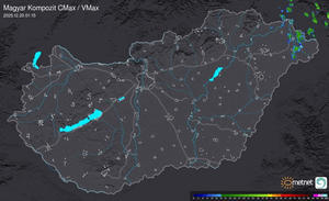
Térképek
Radar
Aktuális hõmérséklet
Aktuális szél
Utolsó kép

Miért nem láttam (még soha) a sarki fényt?
Időjárás-változás | 2024-05-13 08:01
Szabályzat