Meteorológiai társalgó
Hasznos linkek (és egy infó)
TMAX TIPPVERSENY (2026. június vége) >> Sat24 műholdképek
>> Sat24 Magyarország mozgó műholdkép
>> Magyarországi radarképek archívuma
>>Tippelek az előrejelzési verseny aktuális fordulójában!
>>Rádiószondás felszállások élő követése!
>>Észlelés (közeli villámlás, jégeső, viharos szél, villámárvíz, szupercella, tuba, porördög, tornádó, víztölcsér, viharkár) beküldése a szupercella.hu-nak!
----------
Képek beillesztése esetén kérjük azokat megvágni, reklámok, mobilok fejléce, stb. csak feleslegesen foglalja a helyet és áttekinthetetlenné teszi az oldalt - a vágatlan képek ezért törlésre kerülnek.
Fotózáskor kérjük a mobilt fektetve használni, egy keskeny de magas kép egyrészt szintén sok helyet foglal, másrészt a kép sem túl élvezetes.
Köszönjük az együttműködést és a megértést.

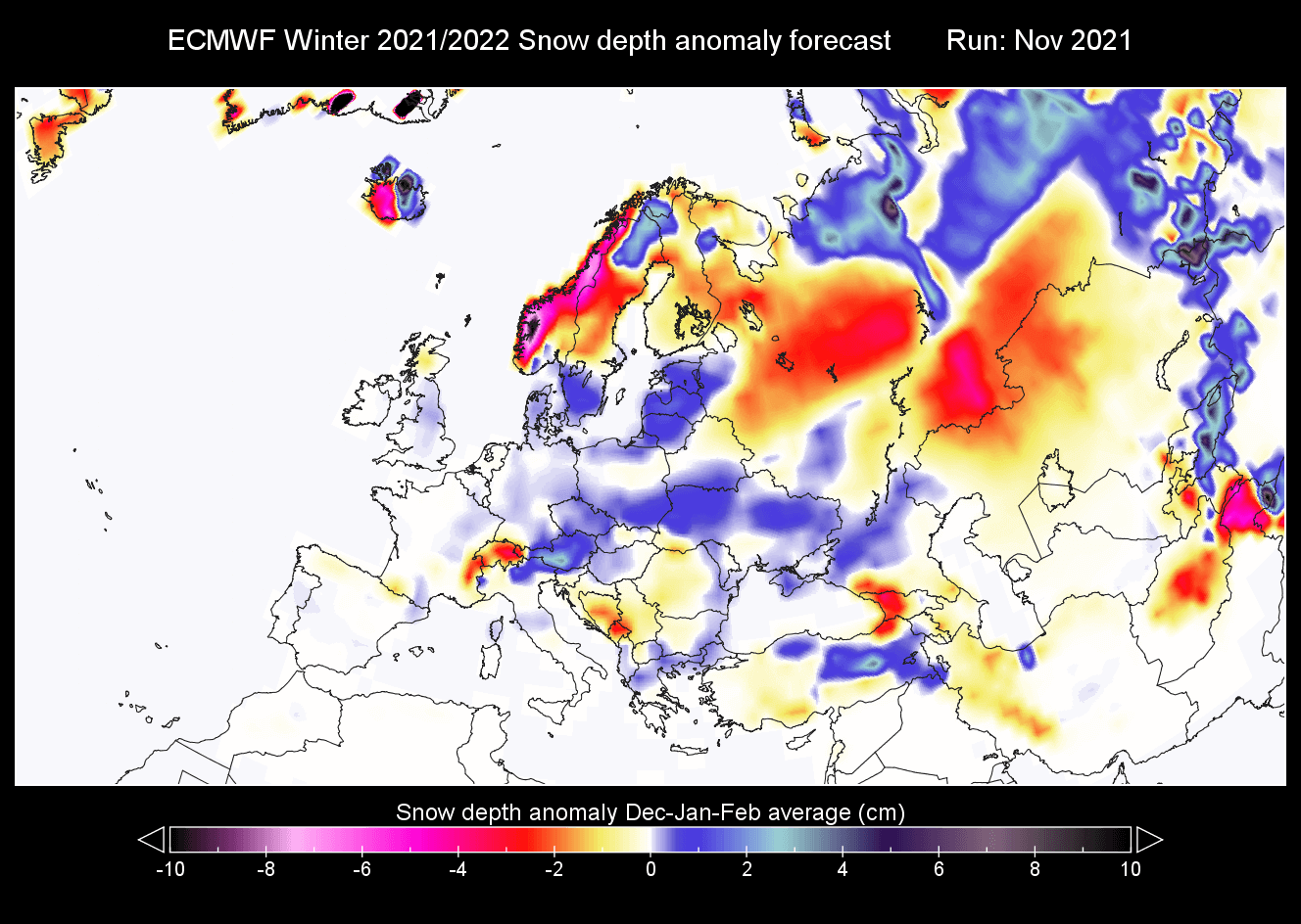
Andrej latolgatott egy újabb litániát a télre nézve: Link
Ebből nehéz konkrétumokat levonni, de az tetszett, hogy pont ez írja: "But this is not a typical positive NAO setup and is also a weaker one. It still allows for winter situations over Europe. Most likely if the high-pressure system in the central Atlantic can take over the North Atlantic for a while, creating a more northerly flow over Europe"
Milyen érdekes, pont ma írtam erről én is "A visszaeső észak-atlanti fáklya mellett a déli AC felfele terjedési próbálkozása folyamatos, hullámokban, azaz a jet nem stabil, ergo zonalitásra majdnem semmi esélyt nem látni a modelleken"
Ez jó lenne így:
"Europe is expected to have warmer than average temperatures over most of the continent, getting stronger towards the east. This, however, does not mean that there will be no cold fronts and colder days. It just implies that cold fronts and colder air mass intrusions will be less frequent over the region. Western Europe is likely to see more frequent colder air intrusions than eastern Europe."
ECM kevésbé, UKMO és CFS erősebben zonális telet vízionál.
Remélem, március végére egy újabb pipát tehetünk a "na, erről megint fogalmuk se volt", már most is igen sűrű rubrikába
Ebből nehéz konkrétumokat levonni, de az tetszett, hogy pont ez írja: "But this is not a typical positive NAO setup and is also a weaker one. It still allows for winter situations over Europe. Most likely if the high-pressure system in the central Atlantic can take over the North Atlantic for a while, creating a more northerly flow over Europe"
Milyen érdekes, pont ma írtam erről én is
"A visszaeső észak-atlanti fáklya mellett a déli AC felfele terjedési próbálkozása folyamatos, hullámokban, azaz a jet nem stabil, ergo zonalitásra majdnem semmi esélyt nem látni a modelleken"Ez jó lenne így:
"Europe is expected to have warmer than average temperatures over most of the continent, getting stronger towards the east. This, however, does not mean that there will be no cold fronts and colder days. It just implies that cold fronts and colder air mass intrusions will be less frequent over the region. Western Europe is likely to see more frequent colder air intrusions than eastern Europe."
ECM kevésbé, UKMO és CFS erősebben zonális telet vízionál.
Remélem, március végére egy újabb pipát tehetünk a "na, erről megint fogalmuk se volt", már most is igen sűrű rubrikába
Utolsó észlelés
Térképek
Radar
Aktuális hõmérséklet
Aktuális szél
Utolsó kép
Érdekességek | 2026-07-02 11:26
Szabályzat