Külföldi időjárási események


PERPIGNAN 184 km/h Record
ST PAUL FENOU (66) 174 km/h
MONT AIGOUAL 172 km/h
La Parata 167 km/h Sud
LEUCATE (11) 148 km/h
NARBONNE (11) 141 km/h
Toulouse-Blagnac 119 km/h Ouest
Porto-Vecchio 119 km/h Sud-Ouest
Millau 115 km/h Ouest
Tarbes 109 km/h Ouest
Saint-Girons 107 km/h Ouest
Mont-de-Marsan 104 km/h Nord-Oues
13 órakkor
Link
severe wind gusts
Lège-Cap-Ferret near Cap-Ferret, Gust of 172km/h observed at peninsula of Cap-Ferret, Région Aquitaine
France (44.80 N, 1.15 W)
24-01-2009 (Saturday) 05:00 UTC (+/- 1 hrs.)
based on: information from a report on a website
land use: land land use where event was first observed: land
wind speed: 47.8 m/s
accompanying weather: heavy rain.
direction of movement: W-E
damage to property: electricity cut off
damage to crops and forests: trees down
Damage caused by a larg storm which travelled over France and caused windspeeds up till 172km/h in the Aqitaine -region south of Bordeaux. Inland, winspeeds up to 147km/h (Bordeaux) and 133km/h (Rion les Landes) were measured. See Link for weather report of Cap-Ferret.
report status: as received (QC0)
contact: Bas van de Beek [e-mail]
severe wind gusts
Gijón Port of Gijon, Port of Gijón, Principado de Asturias
Spain (43.54 N, 5.66 W)
24-01-2009 (Saturday) 01:20 UTC (+/- 15 min.)
based on: information from a report by a weather service
land use: land land use where event was first observed: land
intensity: F2 T4
wind speed: 55.24 m/s
it is unclear whether the event was convective.
There are reported many measures over 170 km/h Link Link Link ays=0&postorder=asc&start=2535
report status: as received (QC0)
contact: Guillermo Chica Postigo [e-mail]
severe wind gusts
Gijón Principado de Asturias
Spain (43.54 N, 5.66 W)
24-01-2009 (Saturday) 00:00 UTC (+/- 3 hrs.)
based on: information from a report by a weather service, a report on a website
land use: land land use where event was first observed: land
intensity: F2 T4
wind speed: 55.3 m/s
it is unclear whether the event was convective.
ws reports; collected report v. Wetterzentrale Forum; Link 1525817
report status: as received (QC0)
contact: Thilo Kühne, ESWD management [e-mail]
severe wind gusts
Punta Candeeira A Coruña
Spain (43.77 N, 7.87 W)
23-01-2009 (Friday) 23:07 UTC (+/- 15 min.)
based on: information from a report by a weather service, a report on a website
land use: land land use where event was first observed: land
intensity: F2 T4
wind speed: 59.8 m/s
it is unclear whether the event was convective.
ws report; reported v. Meteored Forum; Link xplosiva+ciclon+extratropical+klaus+2324+enero-t100810.288.h tml
report status: as received (QC0)
contact: Thilo Kühne, ESWD management [e-mail]
Link


Jó lett ez az estofex elõre tegnapra.  NY-Európában többfelé voltak "szever gásztok" a berobbanó ciklon hatására, kivéve a 3-as szektorban.
La Coruna térségében viszont jó kis szél tombolhatott!
NY-Európában többfelé voltak "szever gásztok" a berobbanó ciklon hatására, kivéve a 3-as szektorban. La Coruna térségében viszont jó kis szél tombolhatott!

Áthelyezve innen: Hó- és zivatarlesen (#99719 - 2009-01-24 06:10:36)
Folgarida-Marilleva hóvastagság 220-240 cm és még havazás várható! Kb 50 cm az elkövetkezõ 3 napban! Jó havat mindenkinek! Nekem tuti lesz


Folgarida-Marilleva hóvastagság 220-240 cm és még havazás várható! Kb 50 cm az elkövetkezõ 3 napban! Jó havat mindenkinek! Nekem tuti lesz
Hm de jó!
Szépe erõteljes ez a csapadékzóna, itt nálunk is jó kis csapadék lehet belõle (most nem hogy gyengíteni, hanem inkább erõsíti majd az Alpok, ez már most is látszik).
Burgenlandra 400 m felett már várnak havat is éjjel, talán némi havas esõ itt is eshet majd.
Szépe erõteljes ez a csapadékzóna, itt nálunk is jó kis csapadék lehet belõle (most nem hogy gyengíteni, hanem inkább erõsíti majd az Alpok, ez már most is látszik).
Burgenlandra 400 m felett már várnak havat is éjjel, talán némi havas esõ itt is eshet majd.

Az se rossz!
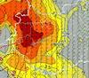
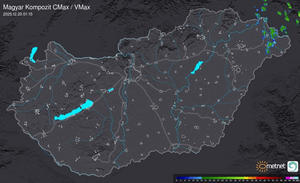
Link Már vörös riasztás van a DNY részeken.
Lentebb megtalálható a radarkép is, kiváncsi leszek, mi jön be az elõrejelzettekhez képest. Lehet hallunk még róla a médiában a napokban...
Link Már vörös riasztás van a DNY részeken.
Lentebb megtalálható a radarkép is, kiváncsi leszek, mi jön be az elõrejelzettekhez képest. Lehet hallunk még róla a médiában a napokban...


Hopp, ott egy zivatar: Link Svájcnál tessék keresni. (A WZ térképeket megnézve kb. 100-200 J/kg CAPE és 0-(-1)-es LI van arrafelé. A ciklon hidegfrontja lehet az okozó.)
Amúgy elképesztõ tendenciák vannak a ciklon miatt, bõ -5 vagy -6 hPa/3h is megvan.
Itt Link pedig a lengyel-cseh határon 40 m/s-os átlagszél, az elõbb megvolt a 42,5 m/s is.
(A WZ térképeket megnézve kb. 100-200 J/kg CAPE és 0-(-1)-es LI van arrafelé. A ciklon hidegfrontja lehet az okozó.)Amúgy elképesztõ tendenciák vannak a ciklon miatt, bõ -5 vagy -6 hPa/3h is megvan.
Itt Link pedig a lengyel-cseh határon 40 m/s-os átlagszél, az elõbb megvolt a 42,5 m/s is.

Innen ered az is, hogy két nappal korábban jön a tavasz a klímaváltozás miatt.....No comment.

Erre nehéz a jóízlés határain belül bármit is mondani... igazi tömegtájékoztatás - butaság az elbutultaknak 

Áthelyezve innen: Hurrikánok és tájfunok (#2339 - 2009-01-23 14:24:4
Ez egy igazán szörnyû definíció, vicces lead-del...
Link
Minihurrikán...a hozzá nem értés Chimborazzo -ja!
Ez egy igazán szörnyû definíció, vicces lead-del...
Link
Minihurrikán...a hozzá nem értés Chimborazzo -ja!


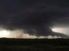
Így van elég kemény szélvihar lesz Fr.o.-nak azon a részén, rövid idõ alatt nagyot zuhan a légnyomás. Elõször, amikor láttam a rózsaszínt, azt hittem a 925-ös szelet linkelted be, de utána láttam hogy ez a 10m-es.. Nem lennék a helyükben.


blizzard—A severe weather condition characterized by high winds and reduced visibilities due to falling or blowing snow.
The U.S. National Weather Service specifies a wind of 30 knots (35 miles per hour) or greater, sufficient snow in the air to reduce visibility to less than 400 m (0.25 miles). Earlier definitions also included a condition of low temperatures, on the order of −7°C (20°F) or lower, or −12°C (10°F) or lower (severe blizzard). The name originated in the United States but it is also used in other countries. In the Antarctic the name is given to violent autumnal winds off the ice cap. In southeastern France, the cold north wind with snow is termed blizzard (see also boulbie). Similar storms in Russian Asia are the buran and purga. In popular usage in the United States and in England, the term is often used for any heavy snowstorm accompanied by strong winds.
Link
According to Environment Canada, a winter storm must have winds of 40 km/h (25 mph) or more, have snow or blowing snow, visibility less than 1 km (about 5⁄8 mile), a wind chill of less than −25 °C (−13 °F), and that all of these conditions must last for 4 hours or more before the storm can be properly called a blizzard.
In the United States, the National Weather Service defines a blizzard as sustained 35 mph (56 km/h) winds which lead to blowing snow and cause visibilities of ¼ mile or less, lasting for at least 3 hours. Temperature is not taken into consideration when issuing a blizzard warning, but the nature of these storms is such that cold air is often present when the other criteria are met.[1] . Temperatures are generally below 0 degrees F.
Other countries, such as the UK, have a lower threshold: the Met Office defines a blizzard as "moderate or heavy snow" combined with a mean wind speed of 30 mph (48 km/h) and visibility below 650 feet (200 m).
Link


Észak-Amerikában így nevezik a telente északról támadó hidegfrontok mögött kialakuló rendkívül heves és látványos hóviharokat, melyek viharos széllel járnak.
Forrás: kislexikon.
Pikk-pakk 1 nap leesik 50 cm hó.
Link
Forrás: kislexikon.
Pikk-pakk 1 nap leesik 50 cm hó.
Link
Az idei télen hiányolom Denverbõl a kemény blizzardokat.Nem emlékszem, hogy lett volna.
Most is +13 fok van ott!
Most is +13 fok van ott!


Hát igen...
Az utóbbi 2 év viharciklonos, tavaszias januárjához képest eléggé másmilyen kép marad meg errõl a januárról a hollandusoknál, meg úgy általában egész Nyugat-Európában. Egy német ismerõsöm, aki Bonnban hallgató, euforisztikus állapotban mesélte, hogy milyen hó volt náluk, valamint -20 fok körüli minimumhõmérsékletek.
Valamelyik reggel még Hamburgban is elõfordult -13 fokos hõmérséklet. Az ottaniak szerint -5 fok is már igencsak zordnak számít.
"For the first time in 12 years, the Netherlands' canals froze this month, bringing the Dutch a heady mix of pandemonium and euphoria."
Link
Ilyet is ritkán látni
Link

Ilyet is ritkán látni
Londonban a héten megtapasztalhatják, milyen egy 950 hPa körüli viharciklon átvonulása! :O

Hoppá csütörtökre a román alföldre befigyelhet a +10+12 fok !
Link
+ Bulgária: egyik héten 30 cm hó másik héten +13 fokos "meleg"
Link
+ Bulgária: egyik héten 30 cm hó másik héten +13 fokos "meleg"
Ez is Izland, az északi rész egy városkája:Link
Élõ webkamera.
Gyakran volt olyan eddig, hogy egyik nap ilyen volt a kép, mint most (hó, hó, hó), másnap elolvadt az egész.Aztán kezdõdött elõrõl.
Élõ webkamera.
Gyakran volt olyan eddig, hogy egyik nap ilyen volt a kép, mint most (hó, hó, hó), másnap elolvadt az egész.Aztán kezdõdött elõrõl.
Ez nagyon érdekes.
Mostanában engem (is) izgat Izland idõjárása. Nem igazán tudok róla túl sokat, de érdekelne, hogy mitõl van ott ennyire szélsõséges idõ.
A fõvárosban (Reykjavíkban)mostanában nagyon enyhe az idõ (Talán ott is érvényesül a Golf-áramlat???), kíváncsi lennék a sziget belsejében mi a helyzet.
Szóval érdekes egy dolog.
Ha valaki tud a témáról egy kicsit többet, szívesen olvasnék róla itt.


Köszönöm!
Szép, nálunk ez tényleg hihetetlen kategória, az biztos, hogy van változékonyság:-)
Szép, nálunk ez tényleg hihetetlen kategória, az biztos, hogy van változékonyság:-)
Utolsó észlelés
Térképek
Radar
Aktuális hõmérséklet
Aktuális szél
Utolsó kép
Indul a MetNet előrejelzési verseny sorozatának 40. sorozata
MetNet | 2024-05-03 15:08
Szabályzat